A comprehensive toolkit for Built Environment Digitalisation

A quick and efficient way to visualise your Construction progress.

An innovative approach to generating and delivering As-Built models.

A tool that will turn your old land survey data right into Digital Twin.
PlainView For Single Users
Today, as-built models are mostly created in 2D layouts.
Structures and services are drawn on a primitive terrain map without the ability to host any additional metadata or to visualize 3D geometry of the object.
Every time an existing structure requires servicing and maintenance, time is wasted on mining and parsing data from scattered resources.
As-built data needs to conform to today’s standards.
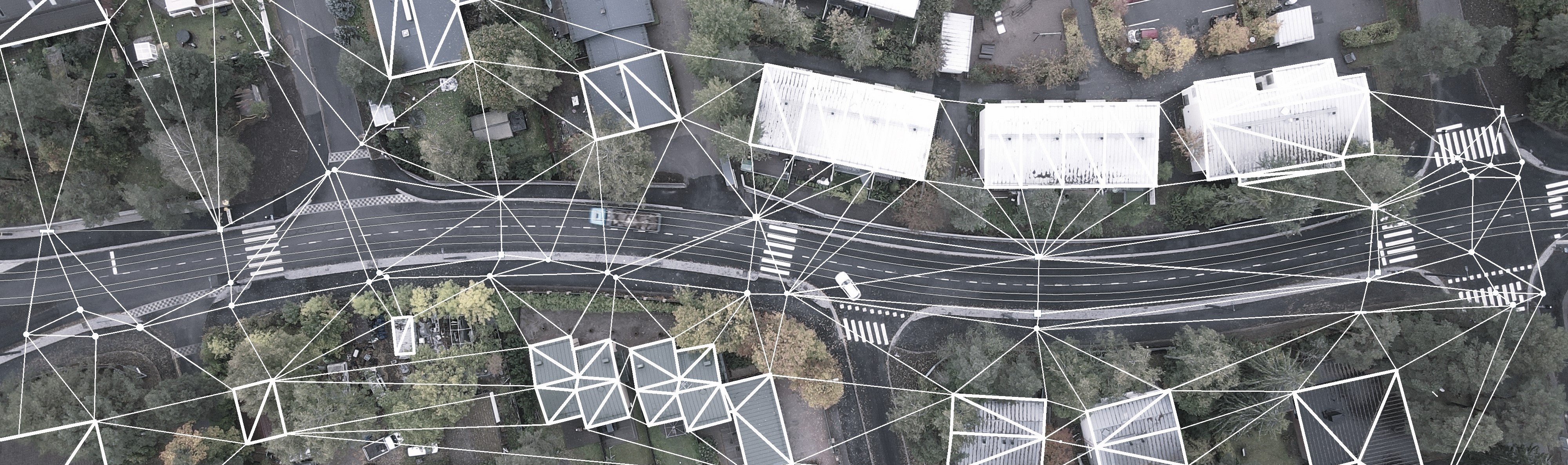
PlainView efficiently transforms an array of 2D survey points and lines into a map-bound 3D model with the ability to enrich with metadata and additional documentation.
This will ultimately increase the quality of the work produced and reduce its final cost.
PlainView For Projects
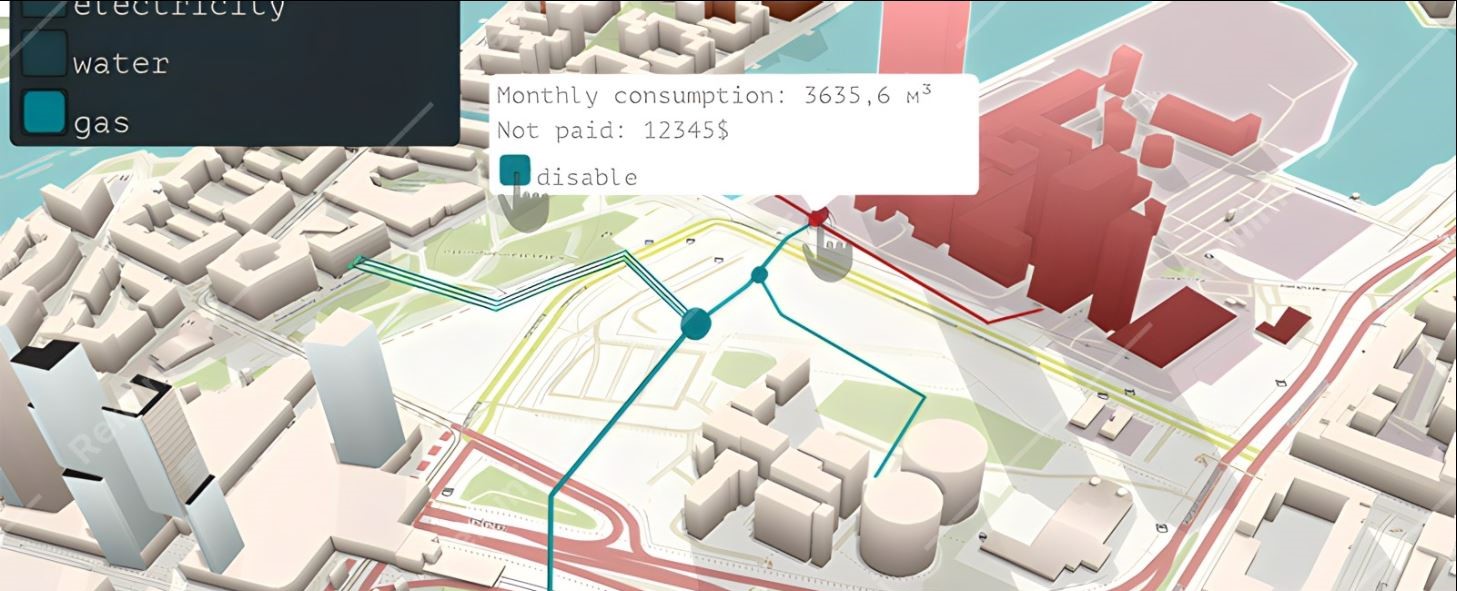
The convenience of inserting all associated metadata and documentation into a 3D model cannot be overrestimated.
The model can caontain an immense quantity of data which, when synchronised together, will serve better data analysis and process optimization.
PlainView, when embedded into the project, will bring the following benefits:
⦁ Flexibility and adaptability to changing BIM inputs and requirements, with the ability to instantly visualise the current situation;
⦁ The ability to tailor 3D object librariy for specific project (e.g. road signs or trees);
⦁ Increasing the value of the final result of the whole modeling segment of the project;
⦁ Ability to simulate the life cycle of a facility, which in turn will enable a complete shift from a reactive approach to facility maintenance to a preventive one;

Survey based location data, volumized 3D geometry and valuable metadata sets.

Attached external QA and maintenance documentation along with photo or video imagery.

Proven compatibility with numerous existing BIM ecosystems.
Here's what we have achieved so far:
⦁ Dynamic 2D to 6D editior for BIM models in LandXML, csv and gt(prn) formats, with plans to expand the amounts of supported formats (IFC, DWG, dotbim...);
⦁ Generating 3D maps of pipelines and cables based on the results of land survey: e.g. pipes from lines, wells from points, etc;
⦁ Generating terrain and landscape 3D maps on the basis of survey data: e.g. road from a center line or a rock surface from scattered survey points;
⦁ Generating 3D terrain objects based on survey data: e.g. a tree or a pole from a scatterpoint or concrete structures, elements of buildings and bridges from lines, etc;
⦁ 3D object library that can be tailored to specific needs (new objects can be easily created with Blender or similar software);
⦁ Linking to a global satellite map with the possibility of functionality extension (different types of maps, editing directly on the map, orthophotography);
⦁ Filling 3D models with metadata: descriptions, encodings, and external links to related documentation;
⦁ Proven compatibility of the outcome models with the main visualisers, editors and construction control systems;

CROWN bridges


The Crown Bridges Light Rail is a new LRT route in Helsinki, Finland, that will connect the areas of Laajasalo, Korkeasaari and Kalasatama to Hakaniemi in 2027.
The parties involved in the Crown Bridges Alliance are the City of Helsinki, Metropolitan Area Transport Ltd, YIT Finland Ltd, NRC Group Finland Oy, Ramboll Finland Ltd, Sweco Finland Ltd and Sitowise Oy.
Digital Twin modelling for this project is focused but not limited to underground- and substructures such as utility pipe networks, concrete foundations and other accompanying structural formations required for a light rail transit.
All Digital Twin modelling of above mentioned structures will comprise about 10km of fully digitalized urban infrastructure and are being done 100% by using PlainView.
OUR GOALS:
With our product we proclaim the transition to a new system of data transfer and storage, from an inefficient folder structure to an informative 3D model with geolocation. The final product will combine a viewer, a 3D and metadata-editor, a master data unit, utility resource manager and a lifespan simulator for a smart city in one cloud-based Digital Twin platform.
Most of today's data banks/model viewers for the construction industry focus on providing data for the design and construction phases of the project, while operation, maintenance and redevelopment phases represent over 90% of the facility's lifespan schedule-wise, and about 70% budget-wise.
According to existing studies, a modern 3D model-based approach to facility management can save up to 50% of the working hours for a maintenance crew and around 5% of yearly expenses. With an effective metadata package suitable for analysis, simulation of facility 'behaviour' and process development, we could finally switch from reactive to fully preventive maintenance approach. That will increase above mentioned percentages by one third.
Progress is unstoppable and what seems impossible today will become part of our routine life tomorrow. Our goal is to create a smart city platform that ensures the continuous circulation of up-to-date data, minimizing loss of time, financial costs and the likelihood of architectural errors.
If you like our idea and are willing to know more about PlainView, please, do not hesitate to get in touch and follow us on social media. Let's work on your BIM projects together.

Send us an e-mail.

Reach out to us through LinkedIn

Or follow us on YouTube.